Define map zoom levels and constraints
-
Choose Go → Config→ Options.
The Options dialog box appears, displaying the Server tab.
-
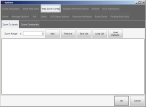
Click the Map Zoom Config tab.
By default, the Zoom To Levels sub-tab is displayed.
Basic
Premium
-
 Define a list of map zoom levels.
 Add a zoom level
- In Zoom Range, type the distance from the Earth you want to zoom to and view a map from.
-
Click Add.
The zoom distance (zoom level) you specified appears in the list of distances.
 Delete a zoom level
- In the list of zoom distances (zoom levels), select the distance you want to delete.
-
Click Remove.
The zoom distance you selected disappears from the list.
 Save the current zoom list
-
Click Save List.
A file browser appears.
-
Use the file browser to navigate to the location you want to save the list of zoom levels to as a file, and to specify a name for the file.
The zoom levels currently displayed on the tab are saved in the file.
 Load a different zoom list
-
Click Load List.
A file browser appears.
-
Use the file browser to navigate to a zoom list file you saved earlier, and to open the file.
The zoom levels in the file you selected appear in the zoom list.
-
 Specify map zoom constraints.
-
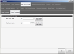
Click the Zoom Constraints sub-tab.
Basic
Premium
- In Min Zoom Level, type the shortest distance from the ground the view of the map can be seen from, in feet, or click Use Current Map Scale to have the zoom level for the map be entered.
- In Max Zoom Level, type the furthest distance from the ground the view of the map can be seen from, in feet, or click Use Current Map Scale to have the zoom level for the map be entered.
-
- Click OK.


